These beautifully detailed, fascinating portrayals of museums, sprawling cities and entire countries are beguiling. They are beautiful works of graphic art. Stunning micro views of some of the world’s most fascinating places complete with the most charming little details to imagine a whole world around. They peer back to a lost world of classic, old-world maps — evoking as much a sense of intrigue and mystery as a sense of place. So hold down zoom and prepare to be captivated by the wanderlust-inducing world of…. cartography.

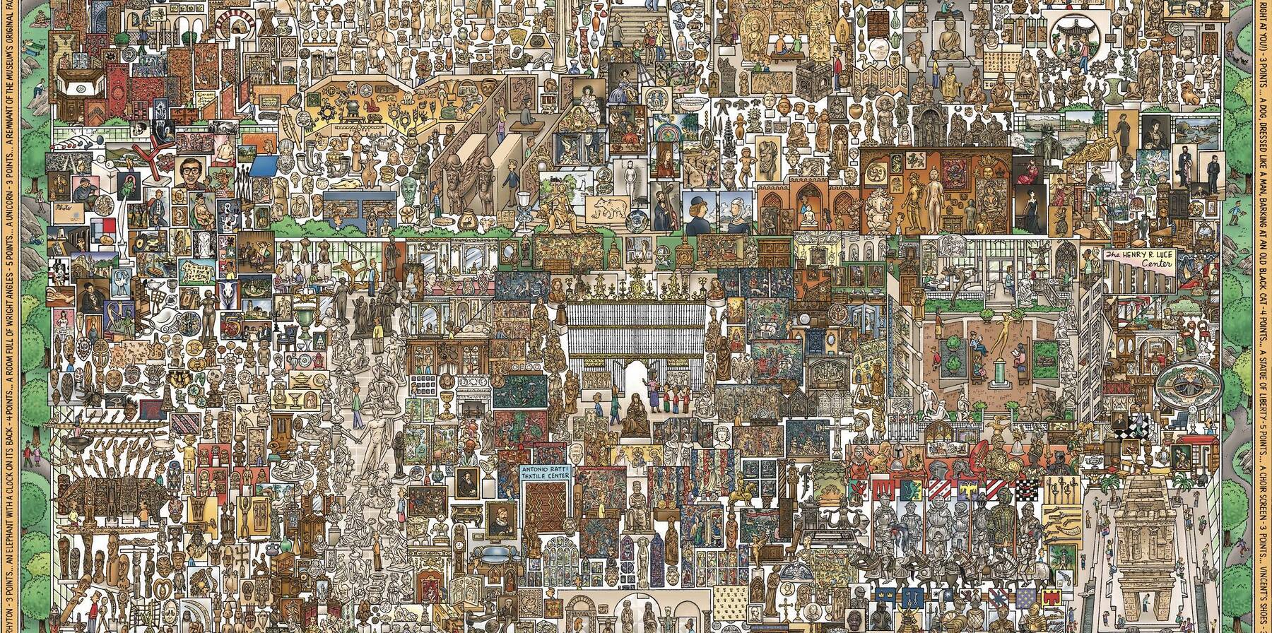
A Vast Hand Drawn Map Of The MET

This wonderful, cartoon-like map of New York’s MET Museum was hand-drawn by John Kerchbaum back in 2004, and charts out every single gallery on one 18-24 inch page, that, while a touch out of date, is still available for free at the museum. It’s complete with charming depictions of families gazing at paintings, armour in the armour galleries, costumes poking out above an Egyptian tomb, couples dining in the restaurant and posing for photos in the lobby, and at least one lady knitting — all set amongst cartoonish renditions of hundreds of the MET’s most cherished pieces.

The full version of the map can be found here in a dizzying digital scan, that includes the “I Spy” puzzles that were added for children visiting the museum, making it a perfect map for those looking for an addictive and educational activity to share with the family. 

The Wonderground Map of London

This charming and humorous map of London depicts the various boroughs, parks and landmarks of central London through colourful illustrations and whimsical puns that play with place names and cliches— with the streets of the map brought to life by hundreds of tiny cartoon Londoners. The map is punctuated by lots of little huts with conical roofs that represent the capital’s tube stations (it was originally intended as a marketing tool for the newly merged tube companies) with the local landmarks grouped around them.

Those familiar with Hyde Park’s Serpentine Lake will note a colourful serpent has taken up residence there, while on the Thames a steamer chases a rowboat under the Albert Bridge and a dockworker on the bank shouts “it’s no good captain, you can’t get under”. And in the top left corner, a monoplane flies upside down in unison with a flock of birds, and a sign on the map's right edge points the way to "Victoria Park, Wanstead Flats, Harwich, Russia and other villages”. In fact, there are so many fascinating little details in this map, that according to press reports from the time, folk would be so enamoured of it that they would ‘miss their trains yet go on smiling' (Daily Sketch, May 1914). The cartographer who created it, Leslie MacDonald Gil created a number of maps for British transport and on behalf of the Empire Marketing Board and often injected a touch of whimsy and wonder into his fascinating creations. 

1920s San Francisco

This fascinating pictorial tourist map of 1920s San Francisco is of particular interest to those living in the city as it forms a colourful starting point from which to map the evolution of San Francisco from the 1920s to now. With its darling little illustrations and colourful renditions of places like the Latin Quarter and China Town, Pacific Heights and the Sunset District, it portrays historical events — such as San Carlos, the first ship to ever enter the Golden Gate — alongside numerous cliches and events from around the city.

On the eastern edge of the map, flocks of trams gather at Market Square, fleets of steamships sit anchored just off the Embarcadero and shipbuilders gather at the Central Basin, while in the middle, cars hurtle along the winding roads of Twin Peaks. On the western edge of the map, seals sit atop Seal Rocks as a car speeds along the back of the beach. It’s fascinating to zoom in on the details to spot surviving historical attractions such as the Prayer Book Cross in Golden Gate Park, first Baptist Church on Waller Street, the domed Civic Centre and the ornate Grace Cathedral. 

Beijing

It seems right to glide from San Francisco to Beijing, as the army officer who drew this map, Frank Dorn, grew up and was and schooled in San Francisco before being stationed in Asia — where amongst other things, he created this incredible depiction of Beijing. A striking element of this particular map is the outer edges that trace the colourful history of the city through numerous colourful vignettes. The vignettes begin with the formation of the original Chou city with a stork carrying the ancient settlement in its beak, and then move through various historically important episodes from Chinese history — from the Mongolian conquest and a visit from a suitcase carrying Marco Polo, to the various dynasties, the boy Emperor Pu Yi, and all the way through to “today” — 1936.

Like the others here, the art style is comic and has a similar worldly wonder as a Tintin comic in its playfully minimal, yet realistic portrayals of the Forbidden and Imperial cities and the ancient walls that surround them, the Black Dragon Pool — complete with a green dragon rising from the water, the summer palace on the very east of the map, and the Yellow Temple just north of the main city. And peppered throughout are charming scenes of monks sitting in prayer, cars hurtling towards pushbikes, peonies sprouting from pots, goats grazing, camels and donkeys carrying supplies, streets depicted pictorially — Lantern Street with lanterns, Silk Street with silk — and throughout it all, the watchful eyes of numerous foxes, bulls and horses. 

Italy’s Wine Regions

This wonderfully colourful travel map of Italy’s wine regions (dating back to 1970) isn’t quite as grandiose or as detailed as others here but it's so charming with its cartoonish renditions of Italian landmarks — the Colleseum, the towers of Emilia-Romagna — and regional cliches alongside oddly drawn little Italians indulging in various activities.

Along the coast there are numerous fishing boats pulling in swordfish alongside happy sea creatures and merfolk. But of most interest, particularly to oenophiles is the labelled regions that along with the little locals and various landmarks, list the specific Italian wines that one will find when exploring that particular region. And while one might not be able to find their way around Italy using this map, it serves as a wonderful guide to gaze at whilst imbibing a glass or two of Chianti, Barolo or Montepulciano.

Become a member to join the conversation!

Become part of the world's leading travel & lifestyle community!